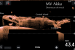
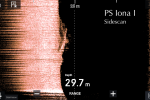
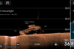
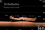
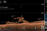
Recent software updates for our fish finder gizmo seem to have improved the quality of output for DownVision and SideVision imaging. Imaging collected in recent months has definitely shown improved quality and definition, in other words we are now seeing elements of man made structure where before it was somewhat fuzzy. We have shown images before for some of the larger wrecks like the Akka which, by their size, have already produced good images. Now the smaller and deeper wrecks are catching up, below are a selection of scans for ten Upper Clyde wrecks.
There are limitations to quality which reduces with greater depth, its a balance, and as with most things in life the quality of output is directly proportional to how deep your pockets are! A good unit can differentiate between a pile of rocks and man made structure such as a wreck and save you time, and perhaps a few fruitless dives.
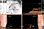
A unit with both side and down scanning capabilities is extremely useful when searching for a wreck. Most modern units work with a windows set-up, this allows you to have different apps playing in each of the windows such as chart, chirp sonar and side scan. So for searching I would have the chart, with the waypoint for the target loaded, probably basic sonar and side scan all running. It is likely the target will first appear of the side scan and you should be able to mark its location with a waypoint. I would then search for the new waypoint with the addition of a window for down scan and home in on the target until I get a good image.
For those of you who have not fallen asleep yet, the above picture graphically demonstrates a typical search set up with windows. Top left is the digital chart, bottom left is chirp sonar, top right is DownVision and bottom right is SideVision. The wreck featured is the bow section of the paddle steamer Princess of Wales which sank off Wemyss Bay in 1888.









Hi, this Downvision sonar on that deeps are from a very good vieuw.
For myself a haven a big collection of sonar pictures from the coast of sourh West Netherland.
Lots of them are make with a Lowrance HDS 10 Gen2 and the most are from Stiucture scan.
Did you have also scan from the Scotlands east coast ?
I am not a diver but collect 40 year information about sunken ships in the North Sea.